
GEOLOGY
Trail Distance:
12.8 miles sticks in my head but other reports are
13 miles according to National Recreation Trail
11.8 miles according to the Barr Trail website
12.6 miles according to the Wikipedia page of Barr Trail
From the trail head to Barr Camp my understanding is that approximately 6.8 miles.
Elevation / Altitude:
Trail Head: 6500
Barr Camp: 10,200
Pike's Peak Summit: 14115 (Not a typo)
Barr Camp: 10,200
Pike's Peak Summit: 14115 (Not a typo)
The signs up top have not been updated as of this writing. I learned this fact well after I came up with the FourteenThousandOneHundredTen name and URL. So the way I see it if the summit is really 14115 then there must be, by scientific law, a spot that is 14110. So I have told others I will keep my goal 14110 and then just over achieve once I get there!
There is a such thing as altitude sickness that under certain circumstances could lead to death.
Gain:
The change in elevation is over 7500 feet is what I have always said; other reports
7900 feet according to the Barr Trail website
7615 doing the math Wikipedia page of Barr Trail
Grade:

CLIMATE
One of the most profound words of advice I have received is that you can perform all the cardiovascular training you want but it is not going to prepare you for the major decrease in Oxygen percentages. There are some, what I would consider expensive, methods for attempting to prepare your body for the higher altitude from the comfort of you low altitude
Here is a link to see what the elevation is at your specific location:
VeloRoutes
And below is chart to show you the percentage oxygen at varying altitudes to compare yours against.

Temperature:
No matter the temperature the sun can cause damage to your skin. Make certain to utilize sunscreen and dress appropriately.
Here is a comparison of the Summit of Pikes Peak compared to that of the trail head located in Manitou Springs.
Summit:

Trail head in Manitou Springs:
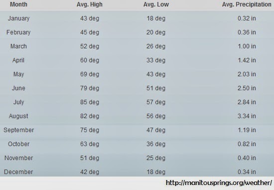
.
Lightning:
According to the NOAA there are on average 27.5 thousand cloud to ground lightning strikes per year in El Paso county Colorado. The numbers in the image below are in the thousands and represent an annual average. Notice El Paso county, home of Barr Trail is by far the second most county for cloud to ground lighting strikes.
Keep in mind too that when hiking up Pike's Peak, based on your altitude, you could end up INSIDE the cloud where lightning is occurring.

Below is table, also from NOAA, that provides statistics on lightening injuries and fatalities. It is critically important to understand what to look for to avoid being caught in a lightening storm and safety measures to take in the event you do become so. My eyes did widen a bit when I saw there were 12 injured by lightening last year in El Paso county. Hovering over that row in the table you will find a link to a story that reports this was a single event on an Army base.
| Year | Month | Day | Time | Total Killed | Total Injured |
| 2013 | July | 31 | 1345 | 0 | 12 |
| 2011 | July | 24 | 1400 | 0 | 5 |
| 2010 | July | 10 | 1240 | 0 | 1 |
| 2008 | June | 24 | 1420 | 0 | 2 |
| 2007 | May | 22 | 1330 | 0 | 1 |
| 2007 | June | 2 | 1330 | 0 | 1 |
| 2007 | September | 2 | 1758 | 1 | 3 |
| 2006 | July | 19 | 1700 | 0 | 1 |
| 2003 | July | 13 | 1040 | 0 | 1 |
| 2003 | July | 25 | 1330 | 0 | 1 |
| 2003 | August | 5 | 1715 | 1 | 0 |
| 2003 | August | 23 | 1400 | 0 | 3 |
| 2001 | August | 5 | 1620 | 0 | 1 |
| 2001 | May | 30 | 1330 | 1 | 3 |
| 2000 | July | 25 | 1159 | 1 | 0 |
| 2000 | July | 28 | 1630 | 0 | 1 |
| 1999 | August | 19 | 1700 | 0 | 8 |
| 1999 | May | 24 | 1406 | 0 | 3 |
| 1999 | May | 24 | 1420 | 0 | 1 |
| 1998 | August | 19 | 1500 | 0 | 1 |
| 1997 | July | 6 | 1230 | 1 | 0 |
| 1997 | June | 13 | 1800 | 0 | 1 |
| 1996 | September | 10 | 1330 | 0 | 1 |
| 1996 | July | 10 | 1720 | 0 | 1 |
| 1996 | July | 20 | 1900 | 1 | 0 |
| 1995 | July | 1 | 1500 | 1 | 1 |
| 1995 | July | 9 | 1615 | 1 | 1 |
| 1995 | June | 2 | n/a | 0 | 1 |
| 1994 | July | 14 | 1500 | 0 | 1 |
| 1994 | June | 29 | 1300 | 0 | 1 |
| 1991 | May | 31 | 1615 | 0 | 3 |
| 1990 | July | 9 | 1615 | 0 | 1 |
| 1990 | July | 9 | 1800 | 0 | 1 |
| 1989 | June | 26 | 1400 | 0 | 1 |
| 1988 | June | 23 | 1845 | 0 | 2 |
| 1987 | August | 28 | Afternoon | 0 | 2 |
| 1987 | June | 9 | 1345 | 0 | 3 |
| 1987 | June | 13 | 1400 | 0 | 1 |
| 1987 | June | 30 | Afternoon | 0 | 1 |
| 1985 | May | 5 | 1745 | 0 | 1 |
| 1985 | May | 18 | 1600 | 1 | 0 |
| 1982 | August | 9 | 1630 | 1 | 0 |
| 1981 | August | 5 | Afternoon | 0 | 1 |
| 1981 | July | 1 | 1715 | 0 | 1 |
| 1981 | May | 26 | 1215 | 0 | 1 |
Strategy
- Educate appropriately
- Train appropriately
- Day of the Hikes start out early, beat the afternoon weather, and know that the average person will go from trail head to summit in 6 to 8 hours
- Dress in layers be prepared for the heat, the cold, the rain, the snow
- Pack light and appropriately
- Keep an eye on the weather
- Know your limits and use good judgement in pushing them
Inadequate Preparedness: Real World Example
If you are planning on ever making this hike then I strongly suggest you watch these videos. While performing some practice hikes this gentleman learned he was not prepared. Examples the viewer will see is that he starts late, had no idea of the distance, over-packed, and did not train appropriately. I intend no insult to this fellow and promote the videos viewing due to the fact they are publicly posted. Another benefit of these videos is some great footage of the trail's views and shots of Barr Camp.
- Night before
- Morning of
- Hike video 1
- Hike video 2
- Hike video 3
- Hike video 4
- Hike video 5
- Hike video 6
- Barr Camp 1
- Barr Camp 2
- Barr Camp 3
- Barr Camp 4
- Barr Camp 5
- Hike Cancelled
Conclusion


